CPP LIVING SHORELINE
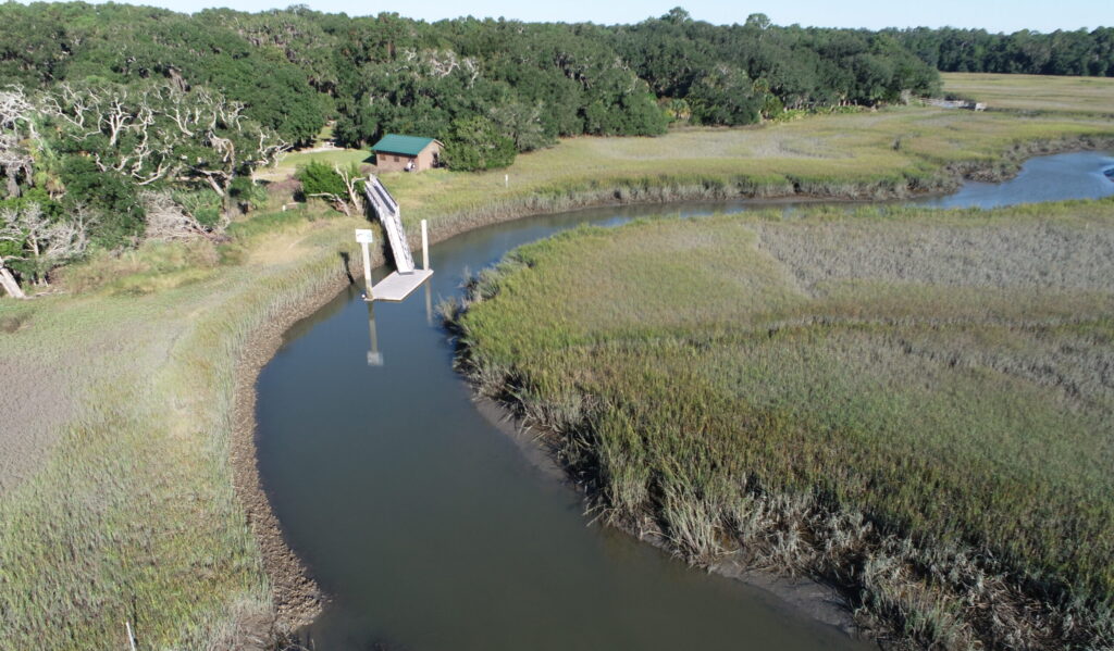
Photo courtesy of GaDNR, Coastal Resources Division


Photo courtesy of GaDNR, Coastal Resources Division
Living shorelines are an alternative form of bank stabilization used in the place of a bulkhead or rip rap. They are designed to mimic natural banks and allow for ecological processes to occur while simultaneously creating essential fish habitat.
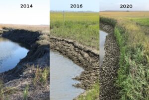
The living shoreline at Cannon’s Point was completed in October 2015 utilizing 8,000 bags of oyster shells, spartina alternaflora plugs, and other native vegetation. This was the fourth demonstration living shoreline project in Georgia and the first to be accessible by vehicles, allowing it to be widely used for educational purposes.
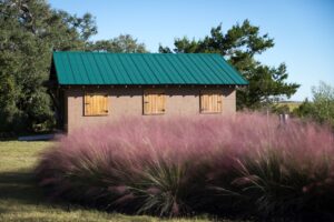 Cannon’s Point Preserve’s living shoreline continues to provide both stability and essential fish habitat in Lawrence Creek. The upland component of the project has a large swath of planted muhly grass (Muhlenbergia capillaris) or sweet grass which blooms during October and through most of November, creating a lovely sea of purple for the fall.
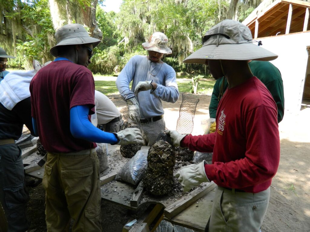
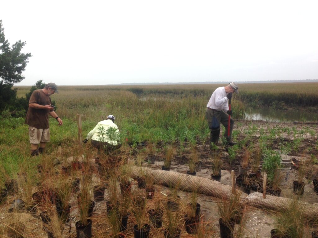
Land Trust volunteers and other partner organizations volunteered an amazing 637 volunteer hours to bag over 5,000 bags of shell. Thank you to St. Simons Land Trust volunteers, Brunswick Job Corps, The Nature Conservancy LEAF interns (2014), AmeriCorps, Boy Scout Troop 207, Bethlehem Christian Academy, Coastal WildScapes, College of Coastal Georgia, the University of Tennessee of Chattanooga, and Melanie Cranford for their incredible volunteer services.
This project provides great educational opportunities for various entities. Some of the groups that have come to learn about the project include, but are not limited to, Georgia Environmental Protection Division, GA DNR Coastal Resources Division permitting section, Honey Creek Episcopal Camp and Conference Center, Georgia Living Shoreline Work Group, and the 2018 Regional Wetland’s Workshop.
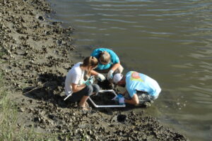 Professor Tate Holbrook and students in his Conservation Biology classes at the College of Coastal Georgia monitored the living shoreline (LSL) site on Lawrence Creek annually from 2014, the year before the LSL was constructed, to 2020. At the end of each growing season, they conduct transect surveys of intertidal benthic invertebrates and plants. Results are shown in the Figures below.
The newly constructed LSL supported a rapid increase in population densities of the eastern oyster (Crassostrea virginica) and smooth cordgrass (Spartina alterniflora). Over the next several years, oyster and Spartina densities remained relatively stable despite Hurricanes Matthew (2016) and Irma (2017), and then increased further in 2019. The results of this study help demonstrate the ecological impacts of LSLs on oyster reef and salt marsh-edge habitats in the highly dynamic estuarine environment of coastal Georgia.
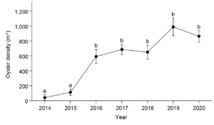
Figure 1. Oyster density (mean ± SE) along the lower bank of Lawrence Creek before and after the living shoreline was installed in 2015. Different letters indicate significant differences between years (Games-Howell post-hoc tests: P < 0.05).
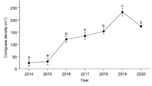
Figure 2. Smooth cordgrass stem density (mean ± SE) along the upper bank of Lawrence Creek before and after the living shoreline was installed in 2015. Different letters indicate significant differences between years (Tukey-Kramer post-hoc tests: P < 0.05).
Thank you to the organizations below, who make up Georgia’s Living Shoreline Working Group, for coming together to discuss ways to improve shoreline resilience on Georgia’s coast.
![]()